About LCMS
LCMS is a nation-wide crisis management system used in The Netherlands to maintain and share a common operational picture supporting large-scale crisis management collaboration. LCMS is used by all 25 safety regions, the majority of the waterboards, Rijkswaterstaat, an increasing number of emergency health care organisations, the Royal Military Police organisation and some drinking water providers.
LCMS supports netcentric collaboration, which is a way of working in which clear agreements are made about sharing information so that decision-making under (crisis) circumstances is always based on an up-to-date, consistent and common operational picture.
LCMS is a web based collaboration environment with a very high level of availability. The environment can be used to share information within an organisation as well as between organisations. It supports maintaining and sharing geographical as well as textual pictures. An overview of the technical set-up of one instance of the LCMS system (e.g., the LCMS system for the waterboards) is depicted below.
Provided Functionalities
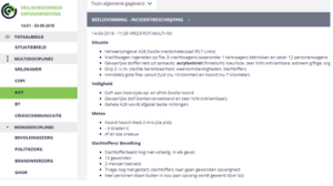
LCMS is made up of number of elements that together form the situational picture. The situational picture is the heart of LCMS where you get a complete overview of all relevant information at once. This can be achieved by means of a textual element as well as by means of geographical visuals. This is where available information is shown for and by all collaborating teams and organisations.
LCMS Tekst
LCMS Text can be used to compose and arrange a coherent, clear and actual situational picture. As a reminder for the information managers, the default content of the textual fields includes a number of themes that are typically relevant in crisis management.
Think of meteorological information, safety of emergency workers and victim overview for example.
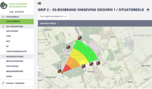
LCMS Plot & Viewer
LCMS Plot & Viewer can be used to maintain a geographical picture of the situation. For each participating team a separate drawing layer is available.
A web-based geographical viewer is part of LCMS Text. This viewer can be used to display relevant map layers and plot layers.
Geo4OOV
The Geo4OOV server supplies LCMS, as well as an increasing number of other systems, with non-dynamic geographical data. LCMS users can find virtually anything they need.